Tuesday, November 28, 2006

Phuket


Phuket: An Amazing Scuba Diving LocationBy: Jose Rossello
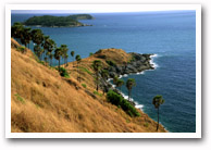
Phuket is located in Thailand and is very highly rated. In fact, it is among the world's top ten scuba diving locations. Exotic culture, adventure both above and below the surface, unforgettable food, Phuket has all the right ingredients for a perfect diving holiday. There are breath taking reefs and remarkable underwater rock formations in addition to the different types of marine life that are found here that provide some amazing opportunities for divers of all levels and persuasions. One can go live-aboard diving and there are also daytrips and plenty of dive points, dive centers as well as dive courses available for the scuba diver. Liveaboard diving in Thailand from Phuket and Khao Lak with liveaboard boats to Similan islands, Richelieu Rock, Phi Phi, Hin Daeng and Hin Muang, are good examples of where you can go to in this great scuba diving location. Phuket and Phi Phi Island, which are among the top 10 scuba diving locations in the world boasts of splendid crystal clear water, awesome rock formations as well as an ecosystem that is vibrant and contains a lot of marine life. The water is also warm having average surface temperatures of 82 degrees Fahrenheit and there are hundreds of different varieties of both stony as well as soft corals surrounded by bright colored fish as well as other creatures of the sea which also includes some large reef fish. While stony corals are the life blood of the reef, soft corals are a prominent part of the reef. In some places they look like vast fields of undersea wildflowers.For those who would like to see big animals there are the Whale Sharks as well as Manta Ray whose sighting is pretty common. In addition, there are also dozens of other picturesque island destinations that lie in close proximity and can be reached by day boats as well as live-aboard cruises, from Phuket. The consistent water temperatures make it possible to go diving throughout the year, right off the coast of Phuket. For those who desire to visit this beautiful scuba diving location, they can look forward to having great food and under expert supervision they may enjoy their stay where the accommodation too, is very comfortable. And those who wish for Scuba certification, this extraordinary scuba diving location will provide many affordable Dive Shops where beginners may learn the basics and others may try out the master instructor certification.Besides its outstanding water treasures, there is a whole lot more available right here at this wonderful scuba diving location in the form of beautiful beaches, gourmet restaurants, vivacious night life as well as a number of other attractions all available where and when one wants it. There are also popular dive centers such as Dive Asia, Colona Diving, Similan Diving Safaris, Moskito Diving, Blue Planet Divers, and Sea Bees Diving plus a number of others for those who desire to try out more of this scuba diving location at Phuket.
Article Source: http://www.webiar.com
Please have a look at our scuba-diving articles, products, resources, and additional information located throughout Scuba-Diving Great Resources. Click here to learn more: Scuba-Diving Location

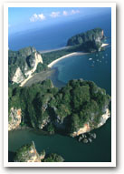
Located approximately 862 kilometers south of Bangkok is Phuket, Thailand's largest island, which is often dubbed as the pearl of the Andaman, or the pearl of the south. Its natural resources- rocky peninsular, limestone cliffs, white powdery beaches, tranquil broad bays and tropical in-land forests contribute to making it the South's wealthiest, busiest, most visited and most popular island and province.
Nestled in the tropical zone off the west coast of the southern part of Thailand in the Andaman Sea and the Indian Ocean, the province covers an area of approximately 543 square kilometers (excluding small islets). It is estimated that Phuket Province covers an area of approximately 590 square kilometers if its 39 other small islands are included. The islands total length, from north to south, is estimated at 48.7 kilometers and approximately 21.3 kilometers wide.
Phuket borders on Phang-nga Province to the north. The other 3 sides are encircled by the Andaman Sea the place where many of the best diving sites are located. The island is connected to Phang-nga Province by Sarasin Bridge and Thep Krasattri Bridge.
Staying on the island is easy, as there are only two seasons in a year - the rainy season (May to October) and the hot season (November to April). Visitors are not recommended to travel to Phuket between September and October as they are the wettest months. The best period for a visit, is from November to February, when it is possible to see the clear blue sky, feel the fresh sea breeze and marvel at the crystal clear water while lying on powdery, palm-fringed beaches. Average temperatures ranges between 23°C and 33°C.
Phuket's topology is exceptional with 70 percent of its area covered with mountains which stretch from north to south and the remaining 30 percent being plains located in the central and eastern parts of the island. The island does not have any major rivers except for a total of 9 brooks and creeks.
Phuket is divided into 3 administrative counties namely Amphoe Muang, Amphoe Thalang and Amphoe Kathu.
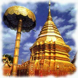
Phuket has a lot more to offer its visitors other than its natural heritage sea, sand, sky, beach, forest, and world renowned diving sites. Sino-Portuguese architecture casts its spell delighting travelers to the city, while Phuket-style hospitality has never failed to impress visitors from all walks of life. In addition, accommodations ranging from world-class resorts to tropical-style bungalows have warmly catered to the different needs of travelers. For seafood lovers, there is a lot more to sample than just Phuket's famous lobster. Altogether, these characteristics have made Phuket a truly unique destination.

History of Phuket
Most geologists believe that the area known as Phuket today was once a cape that extended into the Andaman Sea. Geographical formations gradually changed the capes location, finally detaching it from the mainland.

A famous Greek philosopher, Claudius Ptolemy, was the first person who mentioned the cape in his book written in the year 157. The cape was locally referred to as Jung Ceylon, which was located between latitudes 6 N and 8 N (the present site of Phuket Island). Natives called the place Cha Lang, which evolved to Tha Lang the name of the main town to the north of the island.

As a perfect stopover sheltering traders from monsoons, Jung Ceylon welcomed merchants from India, Persia, Arabia, Burma, China and also Siam. During the 16th century, the island was also a popular trading port for tin with Portuguese, Dutch, English and French traders flocking to the island. This contributed to making the development of mining so unprecedented. Chinese businessmen and miners later migrated to Phuket and soon enjoyed thriving business wealth.
Apart from serving as a meeting point for traders from Europe, Central Asia and China, Phuket also attracted ambitious immigrants, especially those from Portugal and China, to work in the tin mines. With its colorful history, visitors admire the Sino-Portuguese style architecture in the city especially those buildings located along the Thalang and Yaowarat Roads.

Thalang town was surrounded by Burmese troops who invaded the coastal area in 1785. It was under the leadership of Chan, the widow of the governor, and her sister, Muk, who united local residents and successfully fought and drove the invaders out of Phuket. It took over 30 days for the defending troops of Phuket, under the command of Chan and Muk, to claim their victory. As a result of such heroic deeds, noble titles were granted to Chan and Muk as Thao Thep Krasattri and Thao Si Sunthon respectively. To honor them, a monument was established at Tha Ruea Intersection, 12 kilometers to the north of Phuket City in 1966. They are still highly respected by Phuket residents even today.

However, 24 years later, the Burmese succeeded in seizing Thalang causing many local residents to flee to Phang-nga and Krabi. In 1825, some of them returned to re-establish a town and established a rice farming community. On the other hand, the area to the south of the island (Phuket City today) was developed and became a tin trading center.

When Phuket was elevated to a town in 1850, it attracted more immigrants from Thalang and nearby communities. In 1894, Phuket was promoted to be a Monthon administrative unit under the supervision of the central administrative body (located in Bangkok).

In 1902, Phraya Ratsada Korsimbi, a Sino-Thai businessman who contributed to developing the modern city of Phuket was appointed Governor of Phuket. He also helped to improve the welfare of local residents and set up the market system in the countryside. In 1916, Phuket became a province.

The tin mining industry has gradually failed to generate economic growth in Phuket, especially after 1985 when the price of tin fell by half. However, with its natural resources, Phuket later emerged as a tourist destination with great potential. This polished pearl of the Andaman is truly a destination that provides visitors with memorable experiences.

The islands long history has shaped the distinctive Phuket of the present with its diverse ethnic groups, culture, architectural influence, and fine cuisine. With approximately 35 percent of the population being comprised of Thai-Muslims, it is possible to see an equal number of Wats (Thai temples) located next to Mosques.

Thursday, November 23, 2006

Chiang mai


Experiencing the merging of the past into the present in Chiang Mai where locals are proud of the city's 700-year history. Its rich traditional heritage and unique culture is a perfect foundation for the development of the city. Chiang Mai is one of the few places in Thailand where it is possible to find in the heart of the city centuries-old chedis and temples next to modern convenience stores and boutique hotels. The original city layout still exists as a neat square surrounded by a moat with vestiges of the fortified wall and its four main gates offering prime access to the old town.
For years, tourists have mistaken Chiang Mai as the northern junction and the base from which they can explore other provinces. The phrase "a day in Chiang Mai is enough to see things around" was common. Today, tourists are surprised by the fact that there is always something new to discover Chiang Mai. Intriguing diversity among ethnic tribes coupled with breathtaking scenery makes Chiang Mai one of Asia's most attractive tourist destinations. Two weeks in Chiang Mai may not be long enough for serious travelers.
The old city of Chiang Mai with its fascinating indigenous cultural identity such as diverse dialects, cuisine, architecture, traditional values, festivals, handicrafts and classical dances is a prime location in its own right. In addition, the presence of hill tribes and their wealth of unique cultures enhance Chiang Mai's distinctive diversity.
Chiang Mai is also blessed with pristine natural resources of mountains (dois), waterfalls, and other nature-based tourist attractions. At the same time, Chiang Mai residents are warm, gracious and congenial providing authentic hospitality making visits memorable and meaningful. Moreover, visitors from all walks of life can collect handicrafts of silk, silver and wood produced locally as timeless souvenirs. Chiang Mai is a place where both backpackers and luxury tourists can enjoy themselves to the fullest.


The Past
Chiang Mai literally means new city and has retained the name despite having celebrated its 700th anniversary in 1996. King Meng Rai founded the city as the capital of the Lanna (A Million Rice Fields) Kingdom on Thursday, 12th April 1296 during the same period of time as the establishment of the Sukhothai Kingdom. King Meng Rai the Great conferred with his friends, King Ramkhamhaeng of Sukhothai and King Ngam Muang of Phayao before choosing the site where the capital of the Lanna Kingdom was to be founded.
From then, Chiang Mai not only became the capital and cultural core of the Lanna Kingdom, it was also the centre of Buddhism in northern Thailand. King Meng Rai himself was very religious and founded many of the city's temples, which are still important today.
At the height of its power, the Lanna Kingdom extended its territory far into Burma and Laos, and southwards to Kamphaeng Phet a province above Sukhothai.
The Burmese conquered the Lanna Kingdom in 1556 ending the dynasty founded by King Meng Rai that lasted over 250 years. As Burma had occupied Chiang Mai for nearly 200 years, Burmese architectural influences are visible in many temples. At the end of the 18th century, King Taksin the Great regrouped the Thais in the south and finally drove the Burmese out with the help of King Kawila of Lampang thereby regaining Thai independence from Burma. Chiang Mai was then governed by a succession of princes who ruled the north as a Siamese protectorate under the Chakri dynasty. In the late 19th century, King Rama V appointed a high commissioner in Chiang Mai and it was only in 1939 that Chiang Mai finally came under the direct control of the central government in Bangkok the same time the country was renamed Thailand.
In the past, Chiang Mai was only accessible by river and elephants. More convenient access was achieved only when the railway line was completed in the late 1920's. Moreover, the first motor vehicle driven directly from Bangkok arrived in Chiang Mai in 1932. Such isolation was more favorable to Chiang Mai as it helped to nurture and preserve the unique Lanna culture.When we look at Chiang Mai today, it is the economic, cultural and communications hub of northern Thailand complete with excellent infrastructure, good roads, by passes and road tunnels, and reliable communications infrastructure.


The Setting
Chiang Mai, with an altitude of approximately 310 meters above sea level, is situated approximately 700 kilometers from Bangkok on the Mae Ping River basin. Surrounded by high mountain ranges, the city covers an area of approximately 20,107 square kilometers and is the country's second largest province. Chiang Mai borders Myanmar on the north, Lamphun and Tak Provinces on the south, Chiang Rai, Lampang and Lamphun Provinces on the east and Mae Hong Son Province on the west. The terrain is mainly comprised of jungles and mountains, which are home to the hill tribes. In addition, wildlife and exotic flora may be found in the national parks.
Most of Chiang Mai's mountains are oriented from north to south. Together they create a multitude of streams and tributaries including Mae Chaem, Mae Ngat and Mae Klang. One of Chiang Mai's distinctive features is Doi Inthanon, Thailands highest peak, which is 2,575 meters above sea level. In addition, the province boasts flat, fertile valleys, which spread along the banks of the largest and most important river in Chiang Mai Mae Nam Ping (Ping River) which originates from the Chiang Dao mountain range.

Wednesday, November 22, 2006

Thai product


BackgroundThe idea and concept for the construction of ThaiTambon.comwas initiated in 1999. It aimed at a home page for Tambon or sub-district to encourage rural people to understand and use more internet. The first home page was built for Tambon Tonpao, San Kamphaeng District, Chiang Mai Province and was demonstrated to the public at Chiang Mai and posted ever since until replaced by a web site "ThaiTambon.com" later on.In mid 2000 just about six months before the election, assignment was given to a team to develop and construct a web site called ThaiTambon.com. This web site went officially online on June 24, 2000.Purposes1) To construct a comprehensive database system whichaccommodates necessary information from every Tambon inThailand. The web site will be a resource centre for public use.The design covers Tambon general data, transportation system, official people in charge of administration, data on community and professional group including their products, problems, etc.,highlights on One Tambon One Product (OTOP) Project. Additional information on tourism, hotels and restaurants are prepared for Tambon level and above.2) To use ThaiTambon.com to promote local Thai products for every Tambon, and to facilitate the buy-and-sell procedure. Also, to encourage local communities to improve their products and to join the ThaiTambon.com e-commerce or electronicassisted commerce project.3) To bring internet technology to villages and this is the starting point of the Tambon Internet Project (presently under the responsibility of the Ministry of Interior).4) To help encourage and promote tourism in Thailand down toTambon level. Thus more income will be distributed to rural people. 5) ThaiTambon.com will help rural people to exchange information,ideas, and to improve communication across various Tambon.

November, 2006 .New home pages posted as follows :


Tuesday, November 21, 2006

Krabi Thailand


Krabi at a glance
Located approximately 814 kilometers from Bangkok is Krabi Province, one of most attractive destinations in southern Thailand. Encompassing an area of 4,708 square kilometers, the western border of Krabi is the Andaman Sea, the northern borders are Surat Thani and Phang-nga Provinces, the southern borders are Trang Province and the Andaman Sea and the eastern borders are Nakhon Si Thammarat and Trang Provinces. Krabi is an ideal getaway destination teeming with natural attractions including white sandy beaches, fascinating coral reefs, numerous large and small islands and verdant forests with caves and waterfalls.
Krabi's topography is mostly mountains and highlands separated by plains in some parts. Flowing through Krabi City to the Andaman Sea at Pak Nam Sub-district is Maenam Krabi which is 5 kilometers in length. In addition, there are several canals originating from the province's highest mountain range, Khao Phanom Bencha including Khlong Pakasai, Khlong Krabi Yai and Khlong Krabi Noi. Lush mangrove forests line the canals and the banks of Maenam Krabi particularly before it empties into the Andaman Sea. The provinces sandy soil conditions are suitable for growing various agricultural products, particularly rubber trees, palms, coconuts, cashew nuts and coffee.
Due to the influence of the tropical monsoon, there are only two seasons in Krabi; the hot season from January to April and the rainy season from May to December. Temperatures range between 17 °C and 37 °C.
Krabi is administratively divided into 8 Amphoes (Districts): Amphoe Mueang, Khao Phanom, Khlong Thom, Plai Phraya, Ko Lanta, Ao Luek, Lam Thap, and Nuea Khlong. The provinces jurisdiction covers not only in-land districts and sub-districts, but also extends to more than 130 large and small islands including the world famous Phi Phi Islands.
In addition, Krabi is the location of two world class beaches Ao Nang and Hat Rai Le which offer numerous diving trips, restaurants, shops etc. Additional attractions in the province are stunning limestone cliffs and rock formations which make it a heaven for rock climbers and a National Park located approximately 40 kilometers outside of town with lakes, caves and spectacular natural scenery.
History of Krabi
Some archeologists claim that Krabi City is one of the older settlements in the country as there is archaeological evidence indicating that this area had been home to homosapiens during the prehistoric times or between 25,000 - 35,000 B. C. The assumption has been strongly supported by the discovery of stone tools, ancient colored pictures, beads, pottery and skeletal remains in the provinces cliffs and caves.
In 1200 A.D., the area was known as Ban Thai Samo, one of 12 royal cities that had a monkey as the town symbol. During this period of time, Krabi was under the rule of the Kingdom of Ligor, a city better known today as Nakhon Si Thammarat.
During the reign of King Rama V (1868-1910), the community was known as Pakasai Sub-county and remained under the direct jurisdiction of Nakhon Si Thammarat province.
Around 1872, King Rama V elevated Pakasai Sub-county to Krabi Province with the provincial administration office situated at Krabi-yai Sub-county (currently, the office is located near the estuary at Pak Nam Sub-district) and in 1875, ordered the separation of Krabi Province from Nakhon Si Thammarat Province.
During the present reign, the corps of civil servants, merchants, and the people of Krabi and nearby provinces have collectively organized the construction of a royal residence at Laem Hang Nak Cape which is thirty kilometers west of Krabi Town on the Andaman coast to be presented to His Majesty the King.
Origin of the name Krabi
There are two legends concerning the origin of the name "Krabi". The first is that villagers presented a large ancient sword (or krabi) that was discovered by chance to the governor. Later when a smaller, on discovering a smaller one, it was also presented to the governor. Regarded as sacred and auspicious, the governor decided to keep them in the province. As the process for the establishment of the province was still in progress, the swords were placed crossing each other in Khao Khanap Nam cave. Since then, the crossed swords have remained a part of the provincial seal.
The second legend is that "Krabi" was derived from the name of a local tree known as "Lumphi". The Malay and Chinese merchants mispronunciation of the name to "Ka-lu-bi" or "Kho-lo-bi" finally resulted in "Krabi" (or sword).

Tourismthailand


Chon Buri The Nearest Seaside Retreat

Chonburi, Bangkoks nearest seaside town, is located on the eastern coast of the Gulf of Thailand, only 80 kilometers from Bangkok. The area boasts abundant natural resources, which are highlighted by delightful beaches, local colors, traditions, delicacies and fresh seafood. This is a popular resort among Bangkokians who seek the nearest escape from hectic weekly schedules as Chon Buri has something for everyone. In addition, Chon Buri is the center of the Eastern Seaboard Development Project, with its industrial parks and fishing villages.
Pattaya
Pattaya A Travelers Paradise
Pattaya is nestled along a picturesque bay on the East Coast of the Gulf of Thailand, roughly 170 kilometers southeast of Bangkok. From a fishing village in the 1960's, Pattaya has emerged as the favorite Southeast Asian vacation center. A fascinating escape where tourists, holiday makers and vacationers from around the world unfold an incomparable array of possibilities to unwind during an exotic holiday beach vacation.
Unlike other beach resorts, where natural surroundings are used as magnets to attract tourists, Pattaya makes an all-out attempt to provide the best of everything. Here, everything means everything a tourist can imagine while on holiday: recreation, entertainment, sports, sightseeing and fun. To put it simply, Pattaya is a paradise for everyone, as it has a variety of attractions suitable for all types of visitors. This is the place where you can fill your day, from dusk to dawn, with endless activities, or you may choose to do nothing at all and relax.
The Past
Pattaya's name was originated from the march of Phraya Tak (later known as King Taksin the Great) and his followers from Ayutthaya to Chanthaburi just before the fall of the Ayutthaya Kingdom to the Burmese invaders in 1767.
When Phraya Tak's army arrived in the vicinity of what is Pattaya today, he encountered the troops of Nai Klom who tried to intercept him. When the two leaders met face to face, Nai Klom was awed by Phraya Tak's dignified manner and his army's strict discipline, thereby surrendering without a fight. The place where the two armies confronted each other was later called Thap Phraya, which means the Army of the Phraya. This was later changed to Phatthaya, which happens to mean the wind blowing from the southwest to the northeast at the beginning of the rainy season. Today the spelling of the name has been simplified to Pattaya.
For centuries, Pattaya was a small fishing village almost cut off from the outside world. But a big change occurred on 29 April 1961 when the first group of about 100 American servicemen who would join the Vietnam War arrived in Pattaya for relaxation. Soon, sleepy Pattaya became Thailand's premier and most successful beach resort, which annually attracts hundreds of thousands of pleasure-seeking visitors. A full range of accommodations from super deluxe hotels to bungalows and mini-pocket guesthouses replaced fishermens huts along the beach. Fishing vessels were adapted to become tourist boats and swimmers and sunbathers from various parts of the world frequented the quiet powdery golden beaches. Places of nighttime entertainment have also sprung up and are popular among international tourists.
The Present
Pattaya currently integrates the delights of a 1st class beach resort, city-like dining, shopping and night entertainment facilities with more than 300 assorted hotels, thousands of shops, restaurants and bars. In addition, there are an array of sports and recreational activities including beaches, golf courses, tennis courts, go-kart, gyms for working out, weight lifting and Thai-boxing gear. Pattaya offers a broad range of things to do. During the day, one may enjoy riding elephants or driving humble automatic mini-bikes, monstrous motorcycles, or even monster multicolored convertible Jeeps. Others go for shooting firearms, scuba diving and surfing, deep-sea fishing, speed boats, scooters, water-skiing, parasailing, or aerial sports such as gliding ultra-lights and flying motor-propelled gliders. On the other hand, at night, there are restaurants, bars, theaters, cabaret shows, night clubs, bowling halls, billiard & snooker clubs, exotic erotic shows, discos, sauna & massage parlors, not to cite its absolutely incredible shopping which is available non-stop both day-and-night.
Pattaya Facts
This exotic beach resort welcomes approximately 5 million visitors a year. The friendly and hospitable Thai nature boosts its promotion, frequently bringing back the repeat visitors and constantly increasing the number of newcomers.
Pattaya city is located on the eastern coast of the country at latitude 13 N and longitude 101 E in the area of Chon Buri province. It is 147 kilometers from Bangkok and lies parallel to Sukhumvit Road on its east and the coastline on its west. Pattaya occupies an area of 208.1 sq. km. that is divided into 53.44 sq. kilometers of land and 154.66 sq. kilometers of islands and sea. Its coastline is 15 kilometers long.
Pattaya has a plain on the coast with some high mountains to the south. The area on the east slopes down towards the sea on the west.
Administration
Pattaya City has been administered under a special autonomous system since 1978. It has a status comparable to that of a municipality and is administered separately by the mayor of Pattaya City, who is responsible for making policies, organizing public services, and supervising all employees of Pattaya City Administration.

Monday, November 20, 2006

tourismthailand


The Phra Nakhon Si Ayutthaya or Ayutthaya in short, is one of Thailand's historical and majestic highlights. Serving as the Thai capital for 417 years (1350 1767: Kingdom of Ayutthaya), it was once glorified as one of the biggest cities in the world a Southeast Asia center for civilizations. During the 17th century, most foreign visitors to Ayutthaya, traders or diplomats alike, claimed Ayutthaya to be the most illustrious and glittering city that they had ever visited. The map of Ayutthaya published in 1691 by Simon de la Loub?re in Du Royaume De Siam is proof of such recognition.
The Kingdom of Ayutthaya reached its apex in terms of sovereignty, military might, wealth, culture, and international commerce in the 16th century when the Kingdoms territory was extended far beyond present-day Laos, Cambodia, and Myanmar. Ayutthaya even had diplomatic relations with Louis XIV of France and was courted by Dutch, Portuguese, English, Chinese and Japanese merchants.Visitors can explore and appreciate Thai history in Phra Nakhon Si Ayutthaya, which is situated only 86 kilometers north of Bangkok. Visitors to Ayutthaya can marvel at its grandeur reflected through numerous magnificent structures and ruins concentrated in and around the city island surrounded by Maenam Chao Phraya, Maenam Pa Sak and Maenam Lopburi. More importantly,Phra Nakhon Si Ayutthaya Historical Park, an extensive historical site in the heart of Ayutthaya city, has been included in UNESCO's World Heritage list since 13 December, 1991.

The Past
The Kingdom of Ayutthaya was built and developed in leaps and bounds. The ruins in Ayutthaya that survived the test of time embody both the glorious and ignominious stories of the Kingdom.
This ancient capital of the Kingdom of Ayutthaya, founded in 1350 by King U-Thong, had thirty three kings of different dynasties and reached its peak in the middle of the18th century. A magnificent city with three palaces and over 400 magnificent temples on an island threaded by canals Ayutthaya was truly an impressive city that attracted both Europeans and Asians. After a 15-month siege the Kingdom of Ayutthaya was conquered and completely destroyed by the Burmese in 1767. When King Taksin the Great finally liberated the Kingdom, a new dynasty was established and the capital was moved to Thonburi. The seal of Ayutthaya depicts a conch on a pedestal tray placed in a small castle under a Mun tree. According to legend, King U-Thong, founder of the Kingdom of Ayutthaya, discovered a beautiful conch buried in the ground being prepared for the establishment of the seat of his Kingdom. Consequently, he had a tiny castle built to house the shell. Hence, the provincial seal.

The Present
Today, there are but groups of crumbling ruins and rows of headless Buddhas where once an empire thrived. The temple compounds are still awe-inspiring even in disrepair and a visit here is memorable and a good beginning for those drawn to the relics of history.
The architecture of Ayutthaya is a fascinating mix of Khmer (ancient Cambodian style) and early Sukhothai style. Some cactus-shaped obelisks, called prangs, denote Khmer influence and look something like the famous towers of Angkor Wat. The more pointed stupas are ascribed to the Sukhothai influence. For new arrivals who had limited their visit to Bangkok, similarities may be noted with the riverside Wat Arun, an 18th-century structure that was built in the so-called Ayutthaya style, a melding of Sukhothai Buddhist influences and Hindu-inspired Khmer motifs.
Ayutthaya is administratively divided into 16 districts: Phra Nakhon Si Ayutthaya, Ban Phraek, Bang Ban, Bang Pahan, Bang Pa-in, Amphoe Bang Sai, Bang Sai, Lat Bua Luang, Maha Rat, Nakhon Luang, Phachi, Phak-Hai, Sena, Tha Rua, Uthai and Wang Noi.